White Sands National Park Has a Bomb Problem
When you're a National Park surrounded by a literal bombing range on all sides, you're going to have some management challenges...

When you're a National Park surrounded by a literal bombing range on all sides, you're going to have some management challenges...
The pulse of what's trending on The Parks Channel. Check out the most watched videos.
37°56'4.26"N, 75°22'32.44"W
Assateague Island
Maryland
Virginia
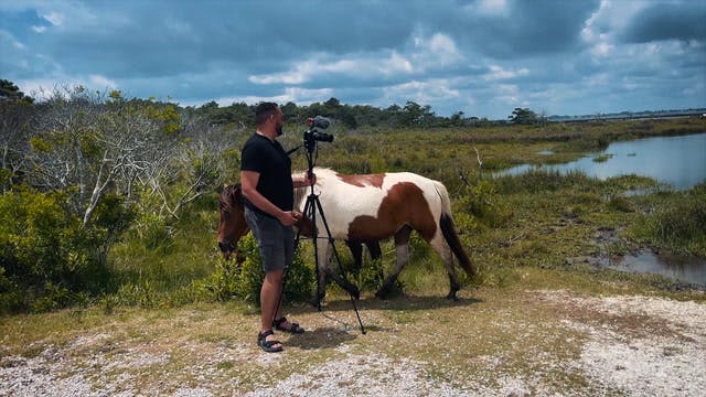
Discover one of the few places in America where horses roam free. Assateague Island is a barrier island between Maryland and Virginia.

Jose Molina
37°56'4.26"N, 75°22'32.44"W
Assateague Island
Maryland
Virginia
Discover one of the few places in America where horses roam free. Assateague Island is a barrier island between Maryland and Virginia.
42°22'50.07"N, 76°52'24.41"W
Watkins Glen State Park
New York
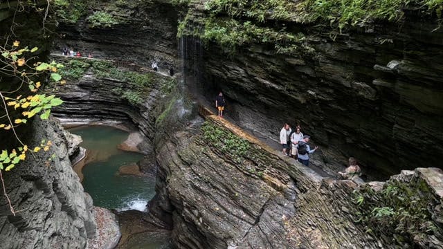
Experience one of the most visited parks in the Finger Lake region of New York State.
Jose Molina
42°22'50.07"N, 76°52'24.41"W
Watkins Glen State Park
New York
Experience one of the most visited parks in the Finger Lake region of New York State.

42°54'37.14"N, 76°47'47.43"W
Women's Rights NHP
New York
From the Statues, to the Church, and Museum, take a tour and learn about the history of Women's Rights in Seneca Falls.
Jose Molina
42°54'37.14"N, 76°47'47.43"W
Women's Rights NHP
New York
From the Statues, to the Church, and Museum, take a tour and learn about the history of Women's Rights in Seneca Falls.

William Howard Taft National Historic Site in Cincinnati, Ohio, preserves the birthplace and childhood home of the 27th President of the United States, who later became Chief Justice of the Supreme Court—the only person to hold both offices. The Victorian-era home offers visitors a glimpse into Taft’s early life and the influences that shaped his career. His grandfather, Alphonso Taft, served as Cincinnati's first mayor, and his father, Charles Phelps Taft, was a U.S. Senator and the 27th Governor of Ohio. From an early age, William Howard Taft was instilled with the importance of hard work and civic duty. He would go on to attend Yale University and Harvard Law School. Exhibits and guided tours provide insights into Taft’s legacy in law and public service, highlighting his contributions to progressive reforms and the judicial system in American history.
Go to park page
The Women's Rights National Historical Park in Seneca Falls, New York, tells the story of the early women's rights movement and the First Women's Rights Convention, which took place in Seneca Falls in 1848. The park includes the Wesleyan Chapel, where the convention was held, as well as the homes of some of the key figures involved in the movement, such as Elizabeth Cady Stanton and Susan B. Anthony. Visitors to the park can learn about the history of the women's rights movement and see some of the documents that were used to spark change. The park is a reminder of how far women have come and how much work still needs to be done in order to achieve true equality.
Go to park page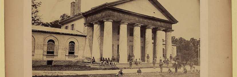
Arlington House, The Robert E. Lee Memorial, is a Greek Revival-style mansion located in Arlington, Virginia, that was once the home of Confederate Army General Robert E. Lee. It overlooks the Potomac River and the National Mall in Washington, D.C. During the American Civil War, the grounds of the mansion were selected as the site of Arlington National Cemetery, and the house itself became a memorial to Lee after his death in 1870. Today, Arlington House is open to the public as a museum operated by the National Park Service.
Go to park page
A lovely wild oasis that's just a short drive from bustling Orlando, the Little Big Econ State Forest is a great getaway for hiking, boating, camping, fishing and wildlife viewing. The Econlockhatchee River stretches for 17 miles through the forest, emptying into the St. Johns River. Be on the lookout for alligators, deer, wild turkeys, bald eagles and lots of other bird species.
Go to park page
The John D. Rockefeller, Jr. Memorial Parkway is one of America’s most scenic highways connecting two of its most visited national parks, Grand Teton and Yellowstone. The parkway is named for the late industrialist, conservationist and philanthropist John D. Rockefeller, Jr., who made significant contributions to several national parks, including Grand Teton, Acadia, Great Smoky Mountains, and Virgin Islands. The parkway provides a natural link between the two national parks and contains features characteristic of both areas. The parkway consists of 24,000 acres and is an integral part of the Greater Yellowstone Ecosystem. It is bordered by Caribou-Targhee National Forest on the west and Bridger-Teton National Forest and the Teton Wilderness on the east. The parkway road extends from the northern end of Grand Teton National Park to West Thumb Geyser Basin in Yellowstone National Park, a distance of 27 miles.
Go to park page
Ouachita National Forest, spanning 1.8 million acres across Oklahoma and Arkansas, is the oldest and largest National Forest in the South. It offers a diverse landscape of rolling hills, lush valleys, and crystal-clear streams. Towering pine and hardwood trees provide a haven for wildlife, including black bears and bald eagles. For thousands of years the Caddo, Quapaw, Osage and Choctaw Nations inhabited this region. Today it is a haven for hikers, with scenic trails like the Ouachita National Recreation Trail. Visitors can also camp, fish, and enjoy scenic drives.
Go to park page
We curate videos that entertain and inform. Join our growing community of creators – or simply explore.
Explore videos
Create your own profile, playlists and checklists.