Women's Rights NHP: How to Visit & What to See
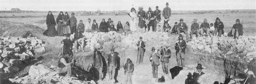
The 1848 Seneca Falls Convention in Seneca Falls, NY was the beginning of the Women's Rights Movement in the United States.

The 1848 Seneca Falls Convention in Seneca Falls, NY was the beginning of the Women's Rights Movement in the United States.
The pulse of what's trending on The Parks Channel. Check out the most watched videos.
37°56'4.26"N, 75°22'32.44"W
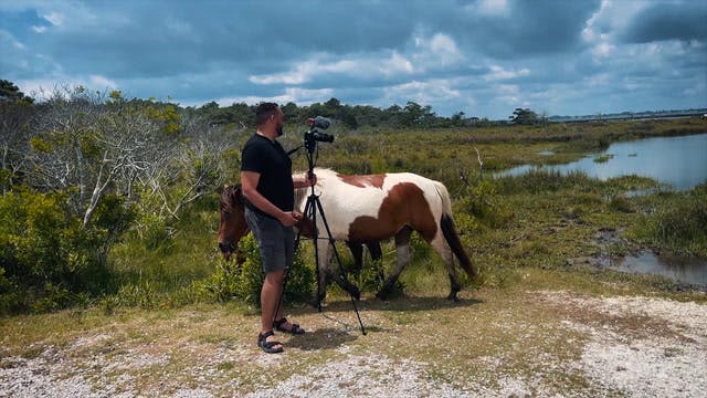
Assateague Island
Maryland
Virginia
Discover one of the few places in America where horses roam free. Assateague Island is a barrier island between Maryland and Virginia.

Jose Molina
37°56'4.26"N, 75°22'32.44"W
Assateague Island
Maryland
Virginia
Discover one of the few places in America where horses roam free. Assateague Island is a barrier island between Maryland and Virginia.
42°22'50.07"N, 76°52'24.41"W
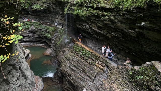
Watkins Glen State Park
New York
Experience one of the most visited parks in the Finger Lake region of New York State.
Jose Molina
42°22'50.07"N, 76°52'24.41"W
Watkins Glen State Park
New York
Experience one of the most visited parks in the Finger Lake region of New York State.

42°54'37.14"N, 76°47'47.43"W
Women's Rights NHP
New York
From the Statues, to the Church, and Museum, take a tour and learn about the history of Women's Rights in Seneca Falls.
Jose Molina
42°54'37.14"N, 76°47'47.43"W
Women's Rights NHP
New York
From the Statues, to the Church, and Museum, take a tour and learn about the history of Women's Rights in Seneca Falls.
Archeologists believe that the quarries at Pipestone National Monument have been in use for over 3000 years. The catlinite, or "pipestone" found at the site is traditionally used to make ceremonial pipes, and the quarries are considered sacred by many tribal nations of North America including the Dakota, Lakota, and other tribes of Native American. In the past, the quarries were considered neutral territory where all Nations could quarry stone for ceremonial pipes. Today, the Monument is open to all visitors, and the quarrying of pipestone still takes place. The stone is hard and difficult to work with, but the results can be beautiful and provocative.
Go to park page
The Charles Young Buffalo Soldiers National Monument commemorates the life of Charles Young (1864-1922), an escaped slave who rose to become a Buffalo Soldier in the US Army and its first African-American colonel. Born into slavery in Kentucky in 1864, he escaped to Ohio with his family as a child. He attended Wilberforce University, where he graduated valedictorian of his class in 1888. He served with distinction in various postings throughout his career, including as military attaché to Liberia from 1897 to 1904. Young retired from the Army in 1917, but rejoined during WWI and attained the rank of colonel. The Monument consists of Colonel Young's House and adjoining 3 acres of land.
Go to park page
Dayton Aviation Heritage National Historical Park was created to celebrate one of the world’s most significant human stories: the mastery of controllable flight. Through perseverance and determination the Wright brothers and Paul Laurence Dunbar were able to overcome obstacles in their lives and leave their respective marks on history. The Wright brothers, Orville and Wilbur, were bicycle shop owners and amateur inventors who became interested in aviation after hearing a lecture by balloonist Samuel Pierpont Langley. They conducted extensive research and experimentation, eventually developing the first successful powered flying machine. Paul Laurence Dunbar was an acclaimed African American poet who overcame poverty and racism to achieve literary success. His work brought him national attention, and he became a role model for future generations of black writers. The park commemorates these three important figures and tells the story of how their accomplishments helped shape the world we live in today.
Go to park page
A magnet for Native Americans and 20th century gangsters alike, Hot Springs National Park is a great place to visit for its incredible views, its rich history, and its therapeutic hot springs. The Tunica, Quapaw, Choctaw and Caddo tribes long believed that soaking in the springs would restore health and vitality. Today you can visit nine historic bathhouses, easing into the same warm waters that drew Al Capone and Bugs Moran during the Prohibition era. The park is also a favorite for bird watchers, with a variety of song birds and raptors. Don't miss the view from the Mountain Tower, an open-air deck at 1,256 feet above sea level.
Go to park page
Situated in the Texas Panhandle, Lake Meredith National Recreation Area is a serene oasis for humans and wildlife alike. The centerpiece of the park is 10,000-acre Lake Meredith, a reservoir created by Sanford Dam on the Canadian River. The lake and its surroundings offer a variety of activities for visitors, including boating, fishing, swimming, camping, hiking, and hunting. Unfortunately, due to record-low water levels, many of these activities have been suspended in recent years. However, five boat launch ramps remain open, and park headquarters are still in operation. With its beautiful scenery and abundant wildlife, Lake Meredith National Recreation Area is a great place to enjoy the outdoors.
Go to park page
Palms Book State Park is a publicly owned nature preserve encompassing 388 acres in the eastern Upper Peninsula of Michigan. The state park is noted for Kitch-iti-kipi, the "Big Spring" of the Upper Peninsula. Michigan's largest freshwater spring, spanning 200 feet across and 40 feet deep, can be seen from above as it wells upward through the pond's bottom of bedrock limestone and sand, creating a continual pattern of random eddies and cross-currents in the depths of the pond. To the Anishinaabe people who were the original inhabitants of much of the Upper Peninsula, this site was a place of mystery and wonder. The flow continues throughout the year at a constant 45 degrees Fahrenheit, gushing more than 10,000 gallons of water a minute from fissures in the underlying limestone.
Go to park page
We curate videos that entertain and inform. Join our growing community of creators – or simply explore.
Explore videos
Create your own profile, playlists and checklists.